
Thank you for supporting this site ❤️
Make a donation
Make a donation
Jumet topographic map
Click on the map to display elevation.
Thank you for supporting this site ❤️
Make a donation
Make a donation
About this map
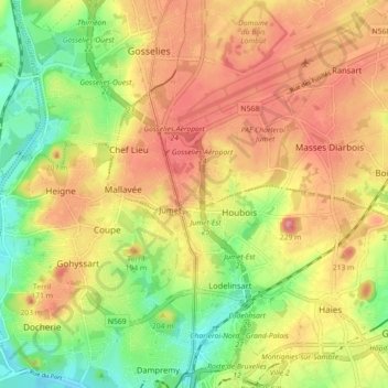
Name: Jumet topographic map, elevation, terrain.
Location: Jumet, Charleroi, Hainaut, Wallonie, 6040, Belgique (50.42717 4.39848 50.46147 4.48764)
Average elevation: 150 m
Minimum elevation: 100 m
Maximum elevation: 199 m
Thank you for supporting this site ❤️
Make a donation
Make a donation
Other topographic maps
Click on a map to view its topography, its elevation and its terrain.