
Thank you for supporting this site ❤️
Make a donation
Make a donation
Lavoir topographic map
Click on the map to display elevation.
Thank you for supporting this site ❤️
Make a donation
Make a donation
About this map
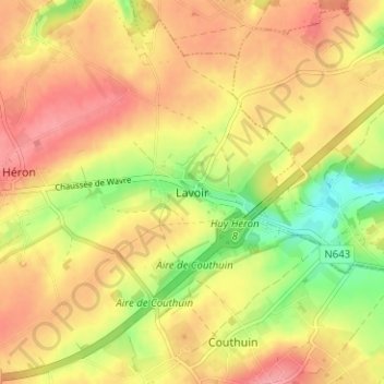
Name: Lavoir topographic map, elevation, terrain.
Location: Lavoir, Huy, Liège, Wallonie, 4217, Belgique (50.52864 5.10558 50.56864 5.14558)
Average elevation: 164 m
Minimum elevation: 112 m
Maximum elevation: 201 m
Thank you for supporting this site ❤️
Make a donation
Make a donation
Other topographic maps
Click on a map to view its topography, its elevation and its terrain.
Thank you for supporting this site ❤️
Make a donation
Make a donation