
Thank you for supporting this site ❤️
Make a donation
Make a donation
Harmignies topographic map
Click on the map to display elevation.
Thank you for supporting this site ❤️
Make a donation
Make a donation
About this map
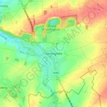
Name: Harmignies topographic map, elevation, terrain.
Location: Harmignies, Mons, Hainaut, Wallonie, 7022, Belgique (50.38764 3.99779 50.42764 4.03779)
Average elevation: 65 m
Minimum elevation: 36 m
Maximum elevation: 95 m
Thank you for supporting this site ❤️
Make a donation
Make a donation
Other topographic maps
Click on a map to view its topography, its elevation and its terrain.