
Thank you for supporting this site ❤️
Make a donation
Make a donation
Al ddayer topographic map
Click on the map to display elevation.
Thank you for supporting this site ❤️
Make a donation
Make a donation
About this map
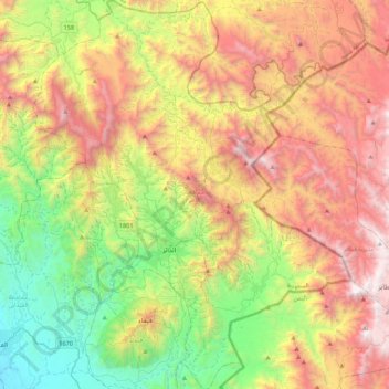
Name: Al ddayer topographic map, elevation, terrain.
Location: Al ddayer, Jazan Region, Saudi Arabia (17.18700 42.98102 17.60155 43.33650)
Average elevation: 1,291 m
Minimum elevation: 197 m
Maximum elevation: 2,741 m
Thank you for supporting this site ❤️
Make a donation
Make a donation
Other topographic maps
Click on a map to view its topography, its elevation and its terrain.