
Nan Province topographic map
Interactive map
Click on the map to display elevation.
About this map
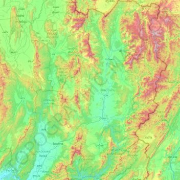
Name: Nan Province topographic map, elevation, terrain.
Location: Nan Province, Thailand (18.01290 100.33634 19.63407 101.35721)
Average elevation: 564 m
Minimum elevation: 118 m
Maximum elevation: 2,050 m
Other topographic maps
Click on a map to view its topography, its elevation and its terrain.
Ban Luang
Thailand > Nan Province > Ban Luang
Ban Luang, Nan Province, Thailand
Average elevation: 380 m