
Make a donation
Eyjafjallajökull topographic map
Click on the map to display elevation.
Make a donation
Eyjafjallajökull
Eyjafjallajökull (Icelandic: (listen); lit. 'glacier of the mountains of the islands') is one of the smaller ice caps of Iceland, north of Skógar and west of Mýrdalsjökull. The ice cap covers the caldera of a volcano with a summit elevation of 1,651 metres (5,417 ft). The volcano has erupted relatively frequently since the Last Glacial Period, most recently in 2010, when, although relatively small for a volcanic eruption, it caused enormous disruption to air travel across western and northern Europe for a week.
Make a donation
About this map
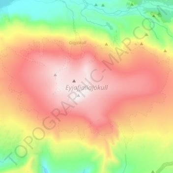
Name: Eyjafjallajökull topographic map, elevation, terrain.
Average elevation: 819 m
Minimum elevation: 138 m
Maximum elevation: 1,628 m
Make a donation
Other topographic maps
Click on a map to view its topography, its elevation and its terrain.
Eyjafjallajökull
Eyjafjallajökull (Icelandic: [ˈeiːjaˌfjatl̥aˌjœːkʏtl̥] ; "glacier of (the mountain) Eyjafjöll"), sometimes referred to by the numeronym E15, is one of the smaller ice caps of Iceland, north of Skógar and west of Mýrdalsjökull. The ice cap covers the caldera of a volcano with a summit elevation of…
Average elevation: 1,459 m
Make a donation
Eyjafjallajökull
Eyjafjallajökull (Icelandic: [ˈeiːjaˌfjat͡ɬaˌjœːkʏt͡ɬ] ; lit. 'glacier of the mountains of the islands'), sometimes referred to by the numeronym E15, is one of the smaller ice caps of Iceland, north of Skógar and west of Mýrdalsjökull. The ice cap covers the caldera of a volcano with a summit…
Average elevation: 1,459 m