
Thank you for supporting this site ❤️
Make a donation
Make a donation
Rieupeyroux topographic map
Click on the map to display elevation.
Thank you for supporting this site ❤️
Make a donation
Make a donation
About this map
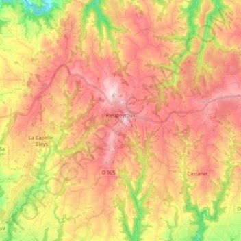
Name: Rieupeyroux topographic map, elevation, terrain.
Average elevation: 613 m
Minimum elevation: 358 m
Maximum elevation: 805 m
Thank you for supporting this site ❤️
Make a donation
Make a donation
Other topographic maps
Click on a map to view its topography, its elevation and its terrain.
Rodez
France > Occitania > Aveyron > Rodez > Rodez
The city has had a longstanding public transport system, the tramway of Rodez having circulated from 1902 to 1920. Nowadays, these journeys are made by buses. Agglobus is the transit network serving the communes of the Communauté d'agglomération du Grand Rodez , nearly 60,000 people, where a multiple…
Average elevation: 586 m
Thank you for supporting this site ❤️
Make a donation
Make a donation