
Cojedes topographic map
Interactive map
Click on the map to display elevation.
About this map
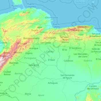
Name: Cojedes topographic map, elevation, terrain.
Location: Cojedes, Central, Venezuela (6.77333 -70.89333 11.89333 -65.77333)
Average elevation: 240 m
Minimum elevation: -1 m
Maximum elevation: 4,474 m
Other topographic maps
Click on a map to view its topography, its elevation and its terrain.
Apartaderos
Venezuela > Cojedes > Municipio Anzoátegui > Apartaderos
Apartaderos, Parroquia Juan de Mata Suárez, Municipio Anzoátegui, Cojedes, 3306, Venezuela
Average elevation: 181 m