
Chappell Hill topographic map
Interactive map
Click on the map to display elevation.
About this map
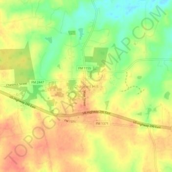
Name: Chappell Hill topographic map, elevation, terrain.
Average elevation: 83 m
Minimum elevation: 53 m
Maximum elevation: 104 m
Other topographic maps
Click on a map to view its topography, its elevation and its terrain.
Brenham
United States > Texas > Washington County
Brenham, Washington County, Texas, United States
Average elevation: 98 m
Independence
United States > Texas > Washington County > Independence
Independence, Washington County, Texas, United States
Average elevation: 106 m
Burton
United States > Texas > Washington County
Burton, Washington County, Texas, United States
Average elevation: 132 m