
Mount Agung topographic map
Interactive map
Click on the map to display elevation.
About this map
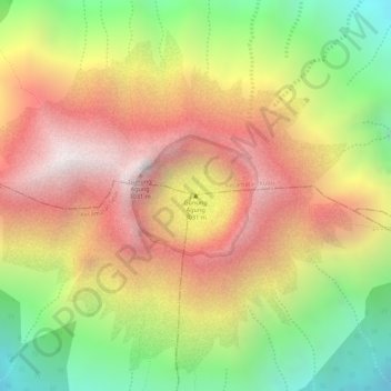
Name: Mount Agung topographic map, elevation, terrain.
Location: Mount Agung, Bali, Indonesia (-8.34064 115.50447 -8.34054 115.50457)
Average elevation: 2,540 m
Minimum elevation: 1,977 m
Maximum elevation: 3,010 m
Other topographic maps
Click on a map to view its topography, its elevation and its terrain.
Dauh Puri Kangin
Indonesia > Bali > Denpasar > Dauh Puri Kangin
Dauh Puri Kangin, Denpasar Barat, Denpasar, Bali, 80232, Indonesia
Average elevation: 26 m