
Make a donation
Hingham topographic map
Click on the map to display elevation.
Make a donation
About this map
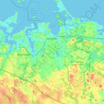
Name: Hingham topographic map, elevation, terrain.
Average elevation: 26 m
Minimum elevation: -5 m
Maximum elevation: 77 m
Make a donation
Other topographic maps
Click on a map to view its topography, its elevation and its terrain.
West Meadow
United States > Massachusetts > Plymouth County > West Bridgewater
Average elevation: 29 m
Make a donation
Make a donation
Kenberma
United States > Massachusetts > Plymouth County > Hull > Nantasket Beach
Average elevation: 2 m
Make a donation
Manomet Heights
United States > Massachusetts > Plymouth County > Plymouth > Manomet
Average elevation: 10 m
Marshfield Center
United States > Massachusetts > Plymouth County > Marshfield
Average elevation: 34 m
Mill Pond
United States > Massachusetts > Plymouth County > Duxbury > Miles Standish Park
Average elevation: 20 m
Make a donation
Eldon B. Kieth Field
United States > Massachusetts > Plymouth County > Brockton
Average elevation: 40 m
Fresh Pond
United States > Massachusetts > Plymouth County > Plymouth > Cedar Bushes
Average elevation: 14 m
Make a donation
Arthur Thurbur Land
United States > Massachusetts > Plymouth County > Duxbury > Baileys Corner
Average elevation: 18 m
Make a donation
Scotland Estates
United States > Massachusetts > Plymouth County > Bridgewater
Average elevation: 28 m
Make a donation
Peddocks Island
United States > Massachusetts > Plymouth County > Hull > Fort Andrews
Average elevation: 1 m
Great Herring Pond
United States > Massachusetts > Plymouth County > Plymouth > Cedarville
Average elevation: 24 m
Make a donation
Make a donation
Make a donation
Make a donation
Green Harbor River
United States > Massachusetts > Plymouth County > Marshfield > Green Harbor
Average elevation: 2 m
Kent Park
United States > Massachusetts > Plymouth County > Marshfield > Kent Park
Average elevation: 13 m
Make a donation
Cranberry Village
United States > Massachusetts > Plymouth County > Carver > Cranberry Village
Average elevation: 30 m
Indian Heights
United States > Massachusetts > Plymouth County > Wareham > Indian Heights
Average elevation: 8 m
Marshfield Hills
United States > Massachusetts > Plymouth County > Marshfield > Marshfield Hills
Average elevation: 29 m
Make a donation