
Thank you for supporting this site ❤️
Make a donation
Make a donation
Madrid Township topographic map
Click on the map to display elevation.
Thank you for supporting this site ❤️
Make a donation
Make a donation
Madrid Township
Although Madrid's northern topography is mountainous, other parts suited cultivation. In 1837, when the population was 351, farms harvested 3,387 bushels of wheat.
Thank you for supporting this site ❤️
Make a donation
Make a donation
About this map
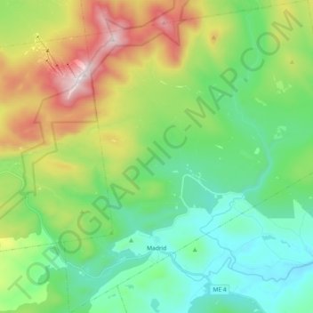
Name: Madrid Township topographic map, elevation, terrain.
Location: Madrid Township, Franklin County, Maine, United States (44.83732 -70.51628 44.96741 -70.34894)
Average elevation: 522 m
Minimum elevation: 199 m
Maximum elevation: 1,246 m
Thank you for supporting this site ❤️
Make a donation
Make a donation
Other topographic maps
Click on a map to view its topography, its elevation and its terrain.
Thank you for supporting this site ❤️
Make a donation
Make a donation
Sandy River Plantation
United States > Maine > Franklin County > Sandy River Plantation
Average elevation: 589 m
Height of Land Scenic Overlook
United States > Maine > Franklin County > Township D > Rangeley Plantation
Average elevation: 601 m
Thank you for supporting this site ❤️
Make a donation
Make a donation