
Landkreis Verden topographic map
Interactive map
Click on the map to display elevation.
About this map
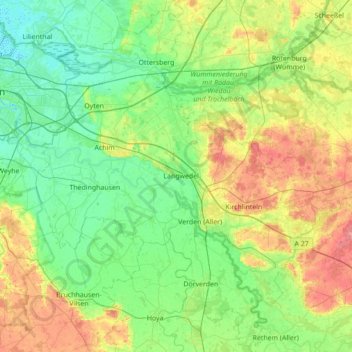
Name: Landkreis Verden topographic map, elevation, terrain.
Location: Landkreis Verden, Nedersaksen, Duitsland (52.76564 8.90371 53.18452 9.46394)
Average elevation: 25 m
Minimum elevation: -1 m
Maximum elevation: 84 m
Other topographic maps
Click on a map to view its topography, its elevation and its terrain.
Achim
Duitsland > Nedersaksen > Landkreis Verden
Achim, Landkreis Verden, Nedersaksen, 28832, Duitsland
Average elevation: 13 m