
Thank you for supporting this site ❤️
Make a donation
Make a donation
Alapan II-B topographic map
Click on the map to display elevation.
Thank you for supporting this site ❤️
Make a donation
Make a donation
About this map
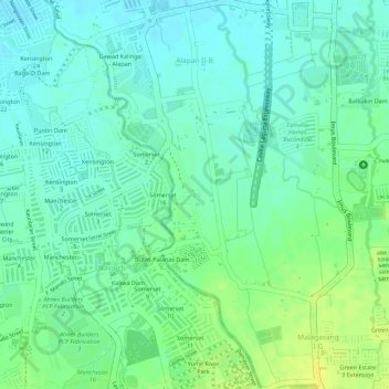
Name: Alapan II-B topographic map, elevation, terrain.
Location: Alapan II-B, Imus, Cavite, Calabarzon, 4103, Philippines (14.38514 120.90017 14.40482 120.91853)
Average elevation: 19 m
Minimum elevation: 10 m
Maximum elevation: 30 m
Thank you for supporting this site ❤️
Make a donation
Make a donation
Other topographic maps
Click on a map to view its topography, its elevation and its terrain.
Thank you for supporting this site ❤️
Make a donation
Make a donation
Thank you for supporting this site ❤️
Make a donation
Make a donation