
Thank you for supporting this site ❤️
Make a donation
Make a donation
Untersiggenthal topographic map
Click on the map to display elevation.
Thank you for supporting this site ❤️
Make a donation
Make a donation
About this map
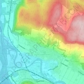
Name: Untersiggenthal topographic map, elevation, terrain.
Location: Untersiggenthal, Bezirk Baden, Aargau, Switzerland (47.48833 8.23285 47.51940 8.28009)
Average elevation: 425 m
Minimum elevation: 322 m
Maximum elevation: 598 m
Thank you for supporting this site ❤️
Make a donation
Make a donation