
Costa Occidental topographic map
Interactive map
Click on the map to display elevation.
About this map
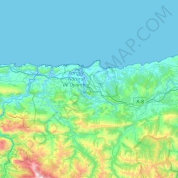
Name: Costa Occidental topographic map, elevation, terrain.
Location: Costa Occidental, Cantabria, España (43.26822 -4.53946 43.42656 -4.04411)
Average elevation: 253 m
Minimum elevation: -4 m
Maximum elevation: 1,884 m
Other topographic maps
Click on a map to view its topography, its elevation and its terrain.
Castro-Urdiales
España > Cantabria > Castro-Urdiales
Castro-Urdiales, Costa Oriental, Cantabria, España
Average elevation: 189 m
Picos de Europa
Picos de Europa, Cabaña Verónica-Urriellu, Cabrales, Liébana, Cantabria, España
Average elevation: 2,290 m
San Vicente de la Barquera
España > Cantabria > San Vicente de la Barquera
San Vicente de la Barquera, Costa Occidental, Cantabria, España
Average elevation: 95 m