
Kyanahalli topographic map
Interactive map
Click on the map to display elevation.
About this map
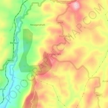
Name: Kyanahalli topographic map, elevation, terrain.
Average elevation: 909 m
Minimum elevation: 762 m
Maximum elevation: 1,037 m
Other topographic maps
Click on a map to view its topography, its elevation and its terrain.
Kadumane
India > Karnataka > Sakaleshapura taluk
Kadumane, Sakaleshapura taluk, Hassan District, Karnataka, India
Average elevation: 949 m
Ichalapura
India > Karnataka > Sakaleshapura taluk
Ichalapura, Sakaleshapura taluk, Hassan District, Karnataka, 573214, India
Average elevation: 917 m
Sakleshpur
India > Karnataka > Sakaleshapura taluk
Sakleshpur, Sakaleshapura taluk, Hassan district, Karnataka, 573134, India
Average elevation: 924 m
Bisle Ghat View Point
India > Karnataka > Sakaleshapura taluk > Arani > Bisale
Bisle Ghat View Point, SH85, Bisale, Arani, Sakaleshapura taluk, Hassan District, Karnataka, 573123, India
Average elevation: 641 m