
Crater Hill topographic map
Interactive map
Click on the map to display elevation.
About this map
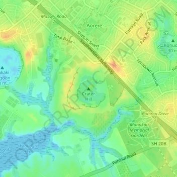
Name: Crater Hill topographic map, elevation, terrain.
Location: Crater Hill, Māngere-Ōtāhuhu, Auckland, 2024, New Zealand (-36.98612 174.82668 -36.98602 174.82678)
Average elevation: 17 m
Minimum elevation: -2 m
Maximum elevation: 38 m
Other topographic maps
Click on a map to view its topography, its elevation and its terrain.
Puketutu Island
New Zealand > Auckland > Mangere-Otahuhu
Puketutu Island, Māngere-Ōtāhuhu, Auckland, New Zealand
Average elevation: 3 m
Ngarango Otainui Island
New Zealand > Auckland > Mangere-Otahuhu
Ngarango Otainui Island, Mangere-Otahuhu, Auckland, New Zealand
Average elevation: 6 m
Mangere Inlet
New Zealand > Auckland > Mangere-Otahuhu
Mangere Inlet, Norana Avenue, Favona, Mangere-Otahuhu, Auckland, 2024, New Zealand
Average elevation: 7 m