
Evol topographic map
Click on the map to display elevation.
About this map
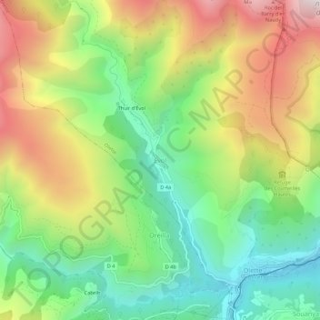
Name: Evol topographic map, elevation, terrain.
Average elevation: 1,055 m
Minimum elevation: 599 m
Maximum elevation: 1,693 m
Other topographic maps
Click on a map to view its topography, its elevation and its terrain.
Lac des Bouillouses
France > Occitania > Pyrénées-Orientales > Angoustrine-Villeneuve-des-Escaldes
Lac des Bouillouses or Llac de la Bollosa is a lake in Pyrénées-Orientales, France. At an elevation of 2017 m, its surface area is 1.49 km².
Average elevation: 2,091 m
Prats-de-Mollo-la-Preste
France > Occitania > Pyrénées-Orientales
Prats-de-Mollo-la-Preste is located in the Pyrenees, 13 km (8.1 mi) from the Spanish border and the Autonomous Community of Catalonia, on the banks of the river Tech, and on the south face of the Canigou at an elevation of 735 meters.
Average elevation: 1,295 m