
Thank you for supporting this site ❤️
Make a donation
Make a donation
Daling topographic map
Click on the map to display elevation.
Thank you for supporting this site ❤️
Make a donation
Make a donation
About this map
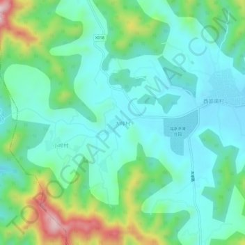
Name: Daling topographic map, elevation, terrain.
Location: Daling, Miyun District, China (40.25151 116.87262 40.29151 116.91262)
Average elevation: 230 m
Minimum elevation: 126 m
Maximum elevation: 547 m
Thank you for supporting this site ❤️
Make a donation
Make a donation
Other topographic maps
Click on a map to view its topography, its elevation and its terrain.