
Make a donation
La Tzoumaz topographic map
Click on the map to display elevation.
Make a donation
About this map
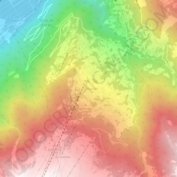
Name: La Tzoumaz topographic map, elevation, terrain.
Location: La Tzoumaz, Riddes, Martigny, Wallis, 1918, Switzerland (46.12444 7.21489 46.16444 7.25489)
Average elevation: 1,467 m
Minimum elevation: 465 m
Maximum elevation: 2,283 m
Make a donation
Other topographic maps
Click on a map to view its topography, its elevation and its terrain.
Martigny
Switzerland > Wallis > Martigny
Martigny (French pronunciation: [maʁtiɲi]; German: Martinach, pronounced [ˈmaʁtiːnaːx]; Latin: Octodurum) is the capital city of the district of Martigny, canton of Valais, Switzerland. It lies at an elevation of 471 meters (1,545 ft), and its population is approximately 20,000 inhabitants (Martignerains…
Average elevation: 917 m
Make a donation
Martigny-Combe
Switzerland > Wallis > Martigny
The municipality is located in the Martigny district. The western boundary of the municipality is the Trient river and the eastern is the Dranse. It climbs from the Rhone valley up to an elevation of 2,700 m (8,900 ft). It lies at the intersection of two major, international transportation routes, the Great…
Average elevation: 1,472 m
Make a donation