
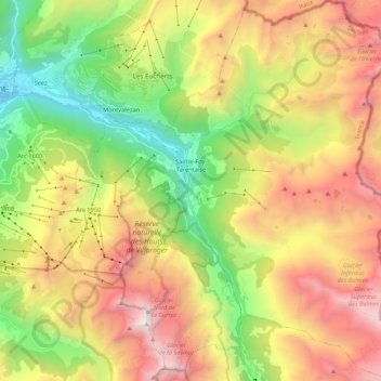
Sainte-Foy-Tarentaise topographic map
Interactive map
Click on the map to display elevation.
About this map
Name: Sainte-Foy-Tarentaise topographic map, elevation, terrain.
Average elevation: 2,136 m
Minimum elevation: 803 m
Maximum elevation: 3,774 m
Son point le plus bas, à Viclaire, est à 890 mètres d’altitude. Le sommet culminant, la Grande Sassière, culmine à 3 747 mètres.
Other topographic maps
Click on a map to view its topography, its elevation and its terrain.
Montalbert
France > Auvergne-Rhône-Alpes > Savoie > Sainte-Foy-Tarentaise
Montalbert, Sainte-Foy-Tarentaise, Albertville, Savoie, Auvergne-Rhône-Alpes, France métropolitaine, 73640, France
Average elevation: 1,601 m