
Coniston topographic map
Interactive map
Click on the map to display elevation.
About this map
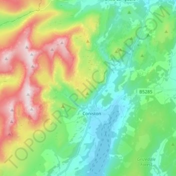
Name: Coniston topographic map, elevation, terrain.
Average elevation: 289 m
Minimum elevation: 45 m
Maximum elevation: 796 m
Other topographic maps
Click on a map to view its topography, its elevation and its terrain.
Lake District National Park
Reino Unido > Inglaterra > South Lakeland
Lake District National Park, Poet’s Walk, Lakes, South Lakeland, Cumbria, North West England, Inglaterra, LA22 9QN, Reino Unido
Average elevation: 206 m
Coniston Water
Reino Unido > Inglaterra > South Lakeland
Coniston Water, The Heald, Coniston, South Lakeland, Cumbria, North West England, Inglaterra, LA21 8AD, Reino Unido
Average elevation: 186 m