
Thank you for supporting this site ❤️
Make a donation
Make a donation
Los Cabos topographic map
Click on the map to display elevation.
Thank you for supporting this site ❤️
Make a donation
Make a donation
About this map
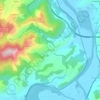
Name: Los Cabos topographic map, elevation, terrain.
Location: Los Cabos, Pravia, Asturias, 33404, Spain (43.49396 -6.12012 43.53396 -6.08012)
Average elevation: 104 m
Minimum elevation: -5 m
Maximum elevation: 446 m
Thank you for supporting this site ❤️
Make a donation
Make a donation
Other topographic maps
Click on a map to view its topography, its elevation and its terrain.