
Emmerthal topographic map
Interactive map
Click on the map to display elevation.
About this map
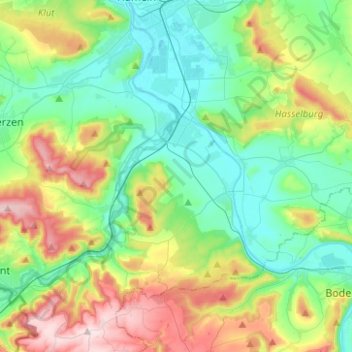
Name: Emmerthal topographic map, elevation, terrain.
Average elevation: 160 m
Minimum elevation: 63 m
Maximum elevation: 377 m
Other topographic maps
Click on a map to view its topography, its elevation and its terrain.
Kleinenberg
Duitsland > Nedersaksen > Landkreis Hameln-Pyrmont > Bad Pyrmont
Kleinenberg, Bad Pyrmont, Landkreis Hameln-Pyrmont, Nedersaksen, 32676, Duitsland
Average elevation: 281 m
Bad Pyrmont
Duitsland > Nedersaksen > Landkreis Hameln-Pyrmont
Bad Pyrmont, Landkreis Hameln-Pyrmont, Nedersaksen, 31812, Duitsland
Average elevation: 218 m
Coppenbrügge
Duitsland > Nedersaksen > Landkreis Hameln-Pyrmont > Coppenbrügge > Coppenbrügge
Coppenbrügge, Landkreis Hameln-Pyrmont, Nedersaksen, 31863, Duitsland
Average elevation: 182 m
Hessisch Oldendorf
Duitsland > Nedersaksen > Landkreis Hameln-Pyrmont
Hessisch Oldendorf, Landkreis Hameln-Pyrmont, Nedersaksen, 31840, Duitsland
Average elevation: 166 m