
Thank you for supporting this site ❤️
Make a donation
Make a donation
Municipio Acosta topographic map
Click on the map to display elevation.
Thank you for supporting this site ❤️
Make a donation
Make a donation
About this map
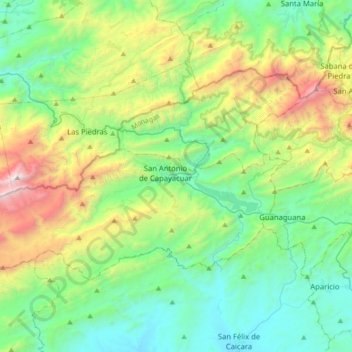
Name: Municipio Acosta topographic map, elevation, terrain.
Location: Municipio Acosta, Estado Monagas, Venezuela (10.01186 -63.93362 10.22316 -63.58444)
Average elevation: 824 m
Minimum elevation: 187 m
Maximum elevation: 2,559 m
Thank you for supporting this site ❤️
Make a donation
Make a donation
Other topographic maps
Click on a map to view its topography, its elevation and its terrain.