
La Candelaria topographic map
Interactive map
Click on the map to display elevation.
About this map
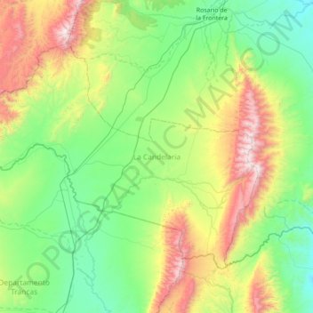
Name: La Candelaria topographic map, elevation, terrain.
Location: La Candelaria, Salta, 4126, Argentina (-26.30680 -65.56397 -25.85976 -64.87135)
Average elevation: 1,112 m
Minimum elevation: 602 m
Maximum elevation: 2,496 m
Other topographic maps
Click on a map to view its topography, its elevation and its terrain.
San Lorenzo
San Lorenzo, Municipio de San Lorenzo, Capital, Salta, Argentina
Average elevation: 1,357 m