
Haldensee topographic map
Interactive map
Click on the map to display elevation.
About this map
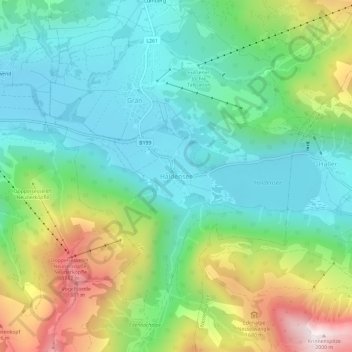
Name: Haldensee topographic map, elevation, terrain.
Average elevation: 1,371 m
Minimum elevation: 1,097 m
Maximum elevation: 1,979 m
Other topographic maps
Click on a map to view its topography, its elevation and its terrain.
Tannheimer Tal
Österreich > Tirol > Bezirk Reutte > Gemeinde Grän
Tannheimer Tal, Gemeinde Grän, Bezirk Reutte, Tirol, 6671, Österreich
Average elevation: 1,433 m
Aggenstein
Österreich > Tirol > Bezirk Reutte > Gemeinde Grän
Aggenstein, Gemeinde Grän, Bezirk Reutte, Tirol, 6673, Österreich
Average elevation: 1,478 m