
Thank you for supporting this site ❤️
Make a donation
Make a donation
Río Mashcón topographic map
Click on the map to display elevation.
Thank you for supporting this site ❤️
Make a donation
Make a donation
About this map
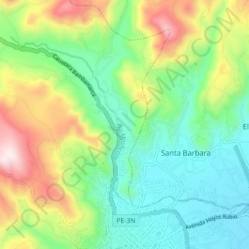
Name: Río Mashcón topographic map, elevation, terrain.
Location: Río Mashcón, Cajamarca, 06000, Perú (-7.14514 -78.55097 -7.10104 -78.48785)
Average elevation: 2,905 m
Minimum elevation: 2,670 m
Maximum elevation: 3,368 m
Thank you for supporting this site ❤️
Make a donation
Make a donation
Other topographic maps
Click on a map to view its topography, its elevation and its terrain.
Thank you for supporting this site ❤️
Make a donation
Make a donation
Thank you for supporting this site ❤️
Make a donation
Make a donation