
Thank you for supporting this site ❤️
Make a donation
Make a donation
Clayton West topographic map
Click on the map to display elevation.
Thank you for supporting this site ❤️
Make a donation
Make a donation
Clayton West
Listed as Clayton, West, the village featured in "A Topographical Dictionary of England" which was published by Samuel Lewis, London, 1848. In 1848 the village had 1440 residents and was described as being 1080 acres belonging to various owners. Mining was listed as the predominant industry, along with the production of silk and worsted goods for clothing. The account states that many large mills had been constructed in the village for this purpose. In 1848 the four places of worship were listed.
Thank you for supporting this site ❤️
Make a donation
Make a donation
About this map
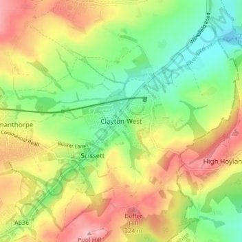
Name: Clayton West topographic map, elevation, terrain.
Average elevation: 150 m
Minimum elevation: 79 m
Maximum elevation: 236 m
Thank you for supporting this site ❤️
Make a donation
Make a donation
Other topographic maps
Click on a map to view its topography, its elevation and its terrain.
Thank you for supporting this site ❤️
Make a donation
Make a donation
Thank you for supporting this site ❤️
Make a donation
Make a donation