
Thank you for supporting this site ❤️
Make a donation
Make a donation
Fond du Lac topographic map
Click on the map to display elevation.
Thank you for supporting this site ❤️
Make a donation
Make a donation
About this map
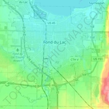
Name: Fond du Lac topographic map, elevation, terrain.
Location: Fond du Lac, Fond du Lac County, Wisconsin, United States (43.71881 -88.49786 43.80921 -88.36637)
Average elevation: 247 m
Minimum elevation: 224 m
Maximum elevation: 335 m
Thank you for supporting this site ❤️
Make a donation
Make a donation
Other topographic maps
Click on a map to view its topography, its elevation and its terrain.
Graham Corners
United States > Wisconsin > Fond du Lac County > Town of Forest
Average elevation: 323 m