
Waltham topographic map
Click on the map to display elevation.
About this map
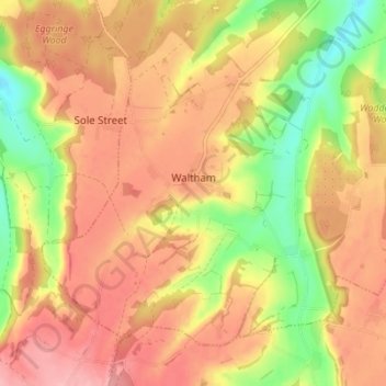
Name: Waltham topographic map, elevation, terrain.
Location: Waltham, Canterbury, Kent, England, United Kingdom (51.17934 0.98937 51.21341 1.05830)
Average elevation: 127 m
Minimum elevation: 58 m
Maximum elevation: 174 m
Other topographic maps
Click on a map to view its topography, its elevation and its terrain.
Shalmsford Street
United Kingdom > England > Kent > Canterbury > Shalmsford Street
Average elevation: 54 m
Reculver Country Park
United Kingdom > England > Kent > Canterbury > Hillborough
Average elevation: 10 m