
Make a donation
Asia Minor topographic map
Click on the map to display elevation.
Make a donation
Asia Minor
Anatolia, also known as Asia Minor, is a large peninsula in West Asia and is the western-most extension of continental Asia as it borders European Türkiye. The land mass of Anatolia constitutes most of the territory of contemporary Türkiye. Geographically, the Anatolian region is bounded by the Turkish Straits to the north-west, the Black Sea to the north, the Armenian Highlands to the east, the Mediterranean Sea to the south, and the Aegean Sea to the west. Topographically, the Sea of Marmara connects the Black Sea with the Aegean Sea through the Bosporus strait and the Dardanelles strait, and separates Anatolia from Thrace in the Balkan peninsula of Southeastern Europe.
Make a donation
About this map
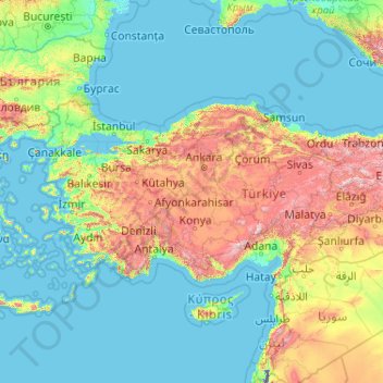
Name: Asia Minor topographic map, elevation, terrain.
Location: Asia Minor, Central Anatolia Region, Turkey (36.01672 26.06337 42.09805 42.59211)
Average elevation: 399 m
Minimum elevation: -216 m
Maximum elevation: 3,492 m
Make a donation
Other topographic maps
Click on a map to view its topography, its elevation and its terrain.
Make a donation
Şanlıurfa
An important consideration in domestic architecture is mahremiyat, which could roughly be translated into English as "privacy" or "intimacy" but which carries stronger implications. This concept is especially important when it comes to relations between men and women – outside the extended family,…
Average elevation: 623 m
Make a donation
Gaziantep
The plan introduced several important changes to the city's transportation network. One of the most important was the addition of a rail line to connect Gaziantep to the national rail system. Up to now, Turkish railway construction had ignored Gaziantep (partly because of its mountainous surroundings); a…
Average elevation: 880 m
Make a donation
Gemlik
Gemlik has a hot-summer Mediterranean climate (Köppen climate classification: Csa') with cool and rainy winters, and hot and dry summers. The driest month is July with an average of 22 mm (0.87 in) of rainfall. The wettest month is December with an average of 98 mm (3.9 in) of precipitation. Although a…
Average elevation: 179 m
Make a donation