
Make a donation
Okuti Valley topographic map
Click on the map to display elevation.
Make a donation
About this map
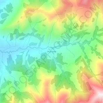
Name: Okuti Valley topographic map, elevation, terrain.
Average elevation: 288 m
Minimum elevation: 5 m
Maximum elevation: 751 m
Make a donation
Other topographic maps
Click on a map to view its topography, its elevation and its terrain.
Little River
New Zealand > Canterbury > Christchurch City > Banks Peninsula Community
Average elevation: 220 m
Le Bons Bay
New Zealand > Canterbury > Christchurch City > Banks Peninsula Community
Average elevation: 244 m
Akaroa
New Zealand > Canterbury > Christchurch City > Banks Peninsula Community
Average elevation: 152 m
Okains Bay
New Zealand > Canterbury > Christchurch City > Banks Peninsula Community
Average elevation: 148 m
Make a donation
Wainui
New Zealand > Canterbury > Christchurch City > Banks Peninsula Community
Average elevation: 203 m
Duvauchelle
New Zealand > Canterbury > Christchurch City > Banks Peninsula Community
Average elevation: 277 m