
Thank you for supporting this site ❤️
Make a donation
Make a donation
Lac-Sainte-Marie topographic map
Click on the map to display elevation.
Thank you for supporting this site ❤️
Make a donation
Make a donation
About this map
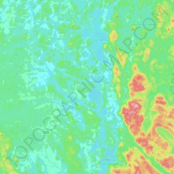
Name: Lac-Sainte-Marie topographic map, elevation, terrain.
Average elevation: 206 m
Minimum elevation: 136 m
Maximum elevation: 546 m
Thank you for supporting this site ❤️
Make a donation
Make a donation
Other topographic maps
Click on a map to view its topography, its elevation and its terrain.
Thank you for supporting this site ❤️
Make a donation
Make a donation
Île Laflamme
Canada > Quebec > La Vallée-de-la-Gatineau > Sainte-Thérèse-de-la-Gatineau
Average elevation: 248 m
Thank you for supporting this site ❤️
Make a donation
Make a donation
Sainte-Thérèse-de-Gatineau
Canada > Quebec > La Vallée-de-la-Gatineau > Sainte-Thérèse-de-la-Gatineau
Average elevation: 180 m
Thank you for supporting this site ❤️
Make a donation
Make a donation
Thank you for supporting this site ❤️
Make a donation
Make a donation