
Thank you for supporting this site ❤️
Make a donation
Make a donation
Bern topographic map
Click on the map to display elevation.
Thank you for supporting this site ❤️
Make a donation
Make a donation
About this map
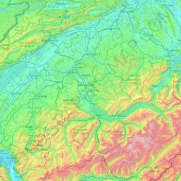
Name: Bern topographic map, elevation, terrain.
Location: Bern, Switzerland (46.32652 6.86148 47.34531 8.45516)
Average elevation: 1,131 m
Minimum elevation: 360 m
Maximum elevation: 4,158 m
Thank you for supporting this site ❤️
Make a donation
Make a donation
Other topographic maps
Click on a map to view its topography, its elevation and its terrain.
Thank you for supporting this site ❤️
Make a donation
Make a donation
Kiental
Switzerland > Bern > Frutigen-Niedersimmental administrative district > Reichenbach im Kandertal
Average elevation: 1,363 m
Thank you for supporting this site ❤️
Make a donation
Make a donation