
Jaro topographic map
Interactive map
Click on the map to display elevation.
About this map
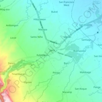
Name: Jaro topographic map, elevation, terrain.
Average elevation: 106 m
Minimum elevation: 36 m
Maximum elevation: 377 m
Other topographic maps
Click on a map to view its topography, its elevation and its terrain.
San Isidro
Philippines > Leyte > Jaro
San Isidro, Jaro, Leyte 2nd District, Leyte, Eastern Visayas, 6527, Philippines
Average elevation: 57 m
Galotan
Philippines > Leyte > Jaro > Galotan
Galotan, Jaro, Leyte 2nd District, Leyte, Eastern Visayas, 6527, Philippines
Average elevation: 63 m