
Thank you for supporting this site ❤️
Make a donation
Make a donation
Cavnic topographic map
Click on the map to display elevation.
Thank you for supporting this site ❤️
Make a donation
Make a donation
About this map
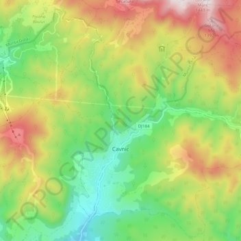
Name: Cavnic topographic map, elevation, terrain.
Location: Cavnic, Maramureș, 435300, Roumanie (47.62996 23.81114 47.69329 23.90826)
Average elevation: 894 m
Minimum elevation: 522 m
Maximum elevation: 1,415 m
Thank you for supporting this site ❤️
Make a donation
Make a donation
Other topographic maps
Click on a map to view its topography, its elevation and its terrain.