
Thank you for supporting this site ❤️
Make a donation
Make a donation
Soutomerille topographic map
Click on the map to display elevation.
Thank you for supporting this site ❤️
Make a donation
Make a donation
About this map
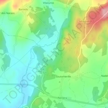
Name: Soutomerille topographic map, elevation, terrain.
Location: Soutomerille, Castroverde, Lugo, Galicia, España (43.01804 -7.40950 43.02815 -7.39135)
Average elevation: 505 m
Minimum elevation: 454 m
Maximum elevation: 606 m
Thank you for supporting this site ❤️
Make a donation
Make a donation
Other topographic maps
Click on a map to view its topography, its elevation and its terrain.