
Thank you for supporting this site ❤️
Make a donation
Make a donation
Hemsbach topographic map
Click on the map to display elevation.
Thank you for supporting this site ❤️
Make a donation
Make a donation
About this map
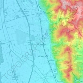
Name: Hemsbach topographic map, elevation, terrain.
Average elevation: 161 m
Minimum elevation: 94 m
Maximum elevation: 399 m
Thank you for supporting this site ❤️
Make a donation
Make a donation
Other topographic maps
Click on a map to view its topography, its elevation and its terrain.
Sinsheim-Steinsfurt / Insenbach
Germany > Baden-Württemberg > Rhein-Neckar-Kreis > Sinsheim
Average elevation: 204 m
Gauangelloch
Germany > Baden-Württemberg > Rhein-Neckar-Kreis > Leimen > Gauangelloch
Average elevation: 221 m
Neckar-Wimmersbach
Germany > Baden-Württemberg > Rhein-Neckar-Kreis > Eberbach
Average elevation: 256 m