
Пожарский район topographic map
Interactive map
Click on the map to display elevation.
About this map
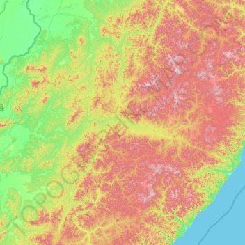
Name: Пожарский район topographic map, elevation, terrain.
Average elevation: 468 m
Minimum elevation: -1 m
Maximum elevation: 1,873 m
Other topographic maps
Click on a map to view its topography, its elevation and its terrain.
Славянка
Russia > Territorio del Litorale > Славянка
Славянка, Хасанский район, Territorio del Litorale, Distretto Federale dell'Estremo Oriente, Russia
Average elevation: 30 m