
Thank you for supporting this site ❤️
Make a donation
Make a donation
Dharampuri topographic map
Click on the map to display elevation.
Thank you for supporting this site ❤️
Make a donation
Make a donation
About this map
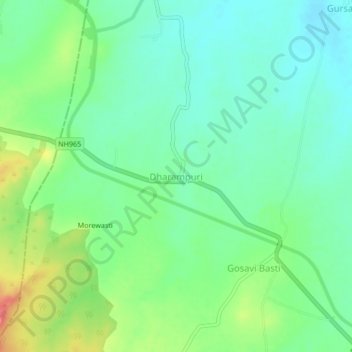
Name: Dharampuri topographic map, elevation, terrain.
Location: Dharampuri, Malshiras, Solapur, Maharashtra, India (17.91997 74.65468 17.95997 74.69468)
Average elevation: 551 m
Minimum elevation: 530 m
Maximum elevation: 593 m
Thank you for supporting this site ❤️
Make a donation
Make a donation
Other topographic maps
Click on a map to view its topography, its elevation and its terrain.