
Make a donation
Fuhlenbrock topographic map
Click on the map to display elevation.
Make a donation
About this map
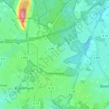
Name: Fuhlenbrock topographic map, elevation, terrain.
Location: Fuhlenbrock, Bottrop, Nordrhein-Westfalen, 46242, Deutschland (51.51251 6.86916 51.55543 6.91539)
Average elevation: 65 m
Minimum elevation: 35 m
Maximum elevation: 170 m
Make a donation
Other topographic maps
Click on a map to view its topography, its elevation and its terrain.
Kirchhellen
Deutschland > Nordrhein-Westfalen > Bottrop
Der Ortsname leitet sich von Kirche auf dem Hügel (Helle) ab und bezieht sich auf den historischen, auf einer Anhöhe im Dorf gelegenen Platz der alten Dorfkirche, die im Jahr 1917 durch einen Brand zerstört wurde. Das heutige Dorfbild wird geprägt von der 1925 eingeweihten, an der Hauptstraße gelegenen…
Average elevation: 56 m
Make a donation
Halde Haniel
Deutschland > Nordrhein-Westfalen > Bottrop
Die Halde Haniel in Bottrop (an der Grenze zu Oberhausen-Königshardt) ist mit 159 m Höhe (184,9 m über Normalnull) eine der höchsten Halden des Ruhrgebiets. Aufgetürmt wurde sie in Form zweier Spiralen durch Abraum der Steinkohlezeche Prosper-Haniel und der Zeche Osterfeld. Im Norden schließt sich die…
Average elevation: 71 m
Tetraeder
Deutschland > Nordrhein-Westfalen > Bottrop
In die Hauptkonstruktion sind Treppen und in verschiedenen Höhen Aussichtsplattformen eingehängt: Die erste Plattform in 18 m Höhe erreicht man über eine als Hängebrücke gebaute Treppe, steil hinauf geht es zur zweiten Plattform in 32 m Höhe. Die dritte Plattform in 38 m Höhe besteht aus einem Ring mit…
Average elevation: 44 m