
Little Island topographic map
Interactive map
Click on the map to display elevation.
About this map
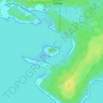
Name: Little Island topographic map, elevation, terrain.
Location: Little Island, Michigan, United States of America (45.78637 -85.50544 45.78922 -85.49913)
Average elevation: 178 m
Minimum elevation: 172 m
Maximum elevation: 195 m
Other topographic maps
Click on a map to view its topography, its elevation and its terrain.
Waterford Township
United States of America > Michigan > Waterford Township
Waterford Township, Oakland County, Michigan, 2800, United States of America
Average elevation: 295 m
Isabella County
United States of America > Michigan
Isabella County, Michigan, United States of America
Average elevation: 261 m
Summit Township
United States of America > Michigan
Summit Township, Jackson County, Michigan, 49203, United States of America
Average elevation: 300 m
Pontiac
United States of America > Michigan > Pontiac
Pontiac, Oakland County, Michigan, United States of America
Average elevation: 290 m
Baraga County
United States of America > Michigan
Baraga County, Michigan, United States of America
Average elevation: 378 m
Lost Lake Woods
United States of America > Michigan > Lost Lake Woods
Lost Lake Woods, Alcona Township, Alcona County, Michigan, United States of America
Average elevation: 248 m
Saginaw County
United States of America > Michigan
Saginaw County, Michigan, United States of America
Average elevation: 193 m
Ingham County
United States of America > Michigan
Ingham County, Michigan, United States of America
Average elevation: 278 m
Ontonagon County
United States of America > Michigan
Ontonagon County, Michigan, United States of America
Average elevation: 334 m
East Lansing
United States of America > Michigan > East Lansing > East Lansing
East Lansing, Ingham County, Michigan, United States of America
Average elevation: 261 m