
Angoulême topographic map
Click on the map to display elevation.
Angoulême
The earliest Cretaceous period - the Cenomanian- is in the relatively low areas (l'Houmeau, the heights of Saint-Cybard, Sillac), at an average altitude of 50m.
About this map
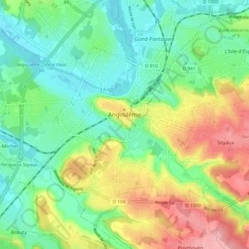
Name: Angoulême topographic map, elevation, terrain.
Average elevation: 72 m
Minimum elevation: 27 m
Maximum elevation: 150 m
Other topographic maps
Click on a map to view its topography, its elevation and its terrain.
Chez Landreau
France > Nouvelle-Aquitaine > Charente > Barbezieux-Saint-Hilaire
Average elevation: 62 m
Chez Landreau
France > Nouvelle-Aquitaine > Charente > Barbezieux-Saint-Hilaire
Average elevation: 62 m