
Thank you for supporting this site ❤️
Make a donation
Make a donation
Chevenon topographic map
Click on the map to display elevation.
Thank you for supporting this site ❤️
Make a donation
Make a donation
About this map
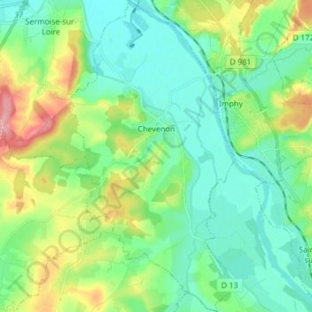
Name: Chevenon topographic map, elevation, terrain.
Average elevation: 201 m
Minimum elevation: 170 m
Maximum elevation: 280 m
Thank you for supporting this site ❤️
Make a donation
Make a donation
Other topographic maps
Click on a map to view its topography, its elevation and its terrain.
Les Loges de Vandenesse
France > Bourgogne – Franche-Comté > Nièvre > Saint-Honoré-les-Bains
Average elevation: 262 m
Thank you for supporting this site ❤️
Make a donation
Make a donation
Le Reux
France > Bourgogne – Franche-Comté > Nièvre > Saint-Honoré-les-Bains > Tussy
Average elevation: 354 m
Thank you for supporting this site ❤️
Make a donation
Make a donation
Le Potin
France > Bourgogne – Franche-Comté > Nièvre > Châteauneuf-Val-de-Bargis
Average elevation: 300 m
Thank you for supporting this site ❤️
Make a donation
Make a donation