
Thank you for supporting this site ❤️
Make a donation
Make a donation
Hambden Township topographic map
Click on the map to display elevation.
Thank you for supporting this site ❤️
Make a donation
Make a donation
About this map
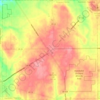
Name: Hambden Township topographic map, elevation, terrain.
Location: Hambden Township, Geauga County, Ohio, United States (41.57051 -81.19118 41.64144 -81.10033)
Average elevation: 371 m
Minimum elevation: 304 m
Maximum elevation: 409 m
Thank you for supporting this site ❤️
Make a donation
Make a donation
Other topographic maps
Click on a map to view its topography, its elevation and its terrain.