
Make a donation
Hawaii topographic map
Click on the map to display elevation.
Make a donation
About this map
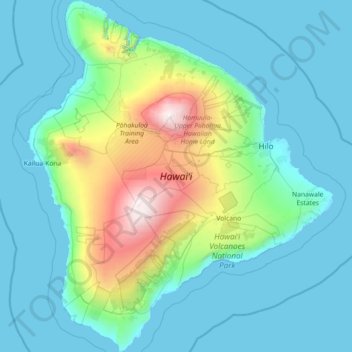
Name: Hawaii topographic map, elevation, terrain.
Location: Hawaii, United States (18.91069 -156.06188 20.26850 -154.80670)
Average elevation: 547 m
Minimum elevation: 0 m
Maximum elevation: 4,187 m
Make a donation
Other topographic maps
Click on a map to view its topography, its elevation and its terrain.
Kula
United States > Hawaii > Maui County
Kula is a district and census-designated place (CDP) of Maui, Hawaii, that stretches across the "up-country", the western-facing slopes of Haleakalā, from Makawao to Kanaio. Most of the residential areas lie between about 500 to 1,100 m (1,600 to 3,600 ft) in elevation. The district has traditionally been…
Average elevation: 740 m
Waipahu
United States > Hawaii > Honolulu County
There are several streams that run through Waipahu, including Waikele Stream and Kapakahi Stream. Waikele Stream runs along the Hawaii Plantation Village and down into Pouhala Marsh Wildlife Sanctuary, which is habitat for several endangered bird species that are endemic to Hawaii. There is roughly 140 feet of…
Average elevation: 164 m
Make a donation
Lisianski Island
United States > Hawaii > Honolulu County
Lisianski Island (Hawaiian: Papa‘āpoho) is one of the Northwestern Hawaiian Islands, with a land area of 384.425 acres (155.571 ha) and a maximum elevation of 40 feet (12 m) above sea level. It is a low, flat sand and coral island about 905 nautical miles (1,041 mi; 1,676 km) northwest of Honolulu, Hawaii.…
Average elevation: 1 m