
Fürstenberg/Havel topographic map
Interactive map
Click on the map to display elevation.
About this map
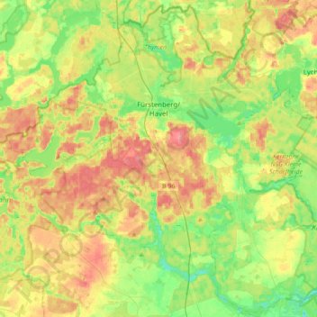
Name: Fürstenberg/Havel topographic map, elevation, terrain.
Location: Fürstenberg/Havel, Oberhavel, Brandenburg, Germany (53.05298 13.02609 53.25103 13.36732)
Average elevation: 67 m
Minimum elevation: 36 m
Maximum elevation: 106 m
Other topographic maps
Click on a map to view its topography, its elevation and its terrain.
Stechlin
Germany > Brandenburg > Oberhavel
Stechlin, Gransee und Gemeinden, Oberhavel, Brandenburg, 16775, Germany
Average elevation: 73 m
Oranienburg
Germany > Brandenburg > Oberhavel > Oranienburg > Oranienburg
Oranienburg, Oberhavel, Brandenburg, 16515, Germany
Average elevation: 39 m
Oranienburg
Germany > Brandenburg > Oberhavel
Oranienburg, Oberhavel, Brandenburg, 16515, Germany
Average elevation: 43 m