
Thank you for supporting this site ❤️
Make a donation
Make a donation
Uda/Uta topographic map
Click on the map to display elevation.
Thank you for supporting this site ❤️
Make a donation
Make a donation
About this map
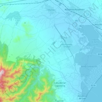
Name: Uda/Uta topographic map, elevation, terrain.
Location: Uda/Uta, Casteddu/Cagliari, Sardinia, 09068, Italy (39.14762 8.83767 39.30597 8.99173)
Average elevation: 89 m
Minimum elevation: -4 m
Maximum elevation: 937 m
Thank you for supporting this site ❤️
Make a donation
Make a donation
Other topographic maps
Click on a map to view its topography, its elevation and its terrain.
Salmagi
Italy > Sardinia > Casteddu/Cagliari > Quartu Sant'Aleni/Quartu Sant'Elena > Terra Mala
Average elevation: 60 m
Monte Arcosu
Italy > Sardinia > Casteddu/Cagliari > Siliqua
Monte Arcosu is a mountain in the Sulcis massif, in southern Sardinia, Italy. It has an elevation of 948 metres (3,110 ft).
Average elevation: 546 m
Thank you for supporting this site ❤️
Make a donation
Make a donation